Morphological and
geological aspects
The Regional Sirente Velino Park is situated
in central Apennines, in Abruzzo, it has an extension
of almost 60.000 ha, entirely in Aquila province.
The Park is situated centrally into an important
system of protected areas, which lay on a vast
Apennines portion. Through North we can find the
National Park of Gran Sasso Mountain and the Laga
Mountains which confines with the National Park
of the Sibillini Mountains; through east-south-east
we can find the National Park of Maiella Mountain;
through south we can find the National Park of
Abruzzo, Lazio and Molise and its external protection
area; through south-west we can find the Regional
Park of Simbruini Mountains which is in Lazio
Region; through west the Natural Regional Reserve
of Duchessa Mountains, in Lazio; through north-west
the Reatini Mountains, and although it is not
a protected area, is an area of undoubted natural
values. The Regional Park Sirente Velino, besides,
houses in its inner surface the Natural Reserve
Orientated of the Velino Mountain.
These protected areas are connected by a faunal
linkage zones system, this means by an important
area system which consents the transit and the
movement of large sized animals from one area
to another. The Regional Park Sirente Velino is
an essential element of the Project E.A.P (Europe
Apennines Park) as central point of a large environmental
retraining and protection zone.
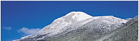
The Park houses two important groups of mountains:
the group of Velino Mountain and the group of
the Sirente Mountain. The first, is the third
Apennines top (2486 m.s.l.m), characterized in
orography, modelled by the glacial events, is
formed by numerous ridges opened in fan on karstic
uplands. The southern portion of the Sirente Velino
Mountain is mostly formed by desert zones; the
reason of the vegetation absence is to be found
into the practice of pastoral activities, into
the trees cut and the reclamation of the Fucino
Lake (second half of the nineteenth century) with
all its climate alteration: for example the determination
of a more continental climate. The second, high
2348 m.s.l.m, is characterized by a large calcareous
level and its summit ends with a long crest, of
20 km. The mountain characterized by two different
sides: the north-east one, steep and rich of deep
valleys and canals, like Valle Lupara and Valle
Inserrata, well known as Canalone Majori which
goes down through the slopes of the karstic levels
and terrace the medium Aterno Valley and, in part,
to the Subequana Valley; the south-west side goes
down sweetly into valleys, small valleys and grasslands,
towards Fucino and the wonderful Gorges of Aielli
e Celano. The two mountains have meagre superficial
water flows because of the karstic and permeable
nature of their soil. Between the two mountains
there are some valleys, like the Aterno Valley,
or rocky sides, like the Upland of the Rocks,
the Pezza Sides, the Sirente grasslands and the
Iano sides. The mountains are both tied to geological
phenomenon of rifting lines. n Pirocene the valleys
were occupied by basins, which were emptied in
the following tectonics fractures and the gorges
opening. The geological nature of the area is
essentially carbonate with calcareous organogenic
of the Cretaceous, potent thickness of slope detritus,
Molasseses Miocene the Quaternario recent grounds
are, anyway, the ones which mostly characterize
the morphologic structure of the territory alluvium
sediments due to the old water basins with glacial
origin, which became, in geologic period, altitude
plans. Besides, are very evident the phenomenon
tied to enormous glacial events; it might be explained
as transforming activities of the landscape due
essentially from the destructive action of the
rocks, and the constructive one(morainic detritus
transport) of: the presence of numerous falling
rocks morainic deposits, glacial cirques and the
formation of the characterizing “U”
valleys. The rocky phenomenon in the Park is,
besides, testified by caves dolines and sink holes:
of particular tourists interest and biospeleologic
are the Stiffe Caves, adjacent to the Park borderland:
the Rio Gamberale is born in Vado Pezza, and after
passing the Rocks Upland, nearby Terranera (Rocca
Di Mezzo - a small village) penetrates into the
soil into the sink holes of Pozzo Caldaio 1253
m.s.l.m and goes on to the Stiffe Caves 66 m.s.l.m.,
with hypogean route of 2600 metres; inside the
caves, its possible to observe lakes, falls also
20 metres high, besides the suggestive stalactites
and stalagmites. It has been a torrent, the Foce,
to engrave the canyon of the Aielli Celano Gorges,
which wind from the Arano Valley, in Ovindoli,
to the Fucino Valley, with a distance of 5 km
and a difference in level of 600 metres, with
steep faces and also about ten metres high, engraved
and transformed by the torrent wash erosion into
Mesozoic calcareous.
From: Natural
Resources in the Sirente Velino Park
Synthesis: Park Archive Documentation
|
 |